在太空中观测火山灰动向
|
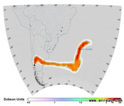
The image was generated on 6 June using data from the Infrared Atmospheric Sounding Interferometer on Eumetsat's MetOp-A satellite. As the eruption continued, the image shows how strong winds initially swept the broad plume of sulphur dioxide northwards and then eastwards across Argentina and out over the southern Atlantic Ocean. Strong westerly winds are common in this region because it lies within the belt of the 'Roaring Forties'. Since there is little land south of 40º, higher wind speeds can develop than at the same latitudes(纬度) in the Northern Hemisphere. Interestingly, over the South Atlantic, the plume take a sharp turn to the north as a pressure system causes the wind to change direction. The Puyehue-Cordón Caulle complex is a chain of volcanoes that includes the Puyehue volcano, the Cordilera Nevada caldera and the Cordón Caulle rift zone. This event appears to have stemmed from the rift zone(裂谷带) and is the most serious since the eruption of 1960, also from the same vent(发泄,出口) . Chile has more than 3000 volcanoes, of which around 80 are currently active. The image represents sulphur dioxide concentrations within the full vertical column of atmosphere. It was generated using data from the interferometer(干涉仪) , which was developed by the French space agency CNES for MetOp-A. |


